Cyclone VAYU likely to landfall in afternoon tomorrow
June 12, 2019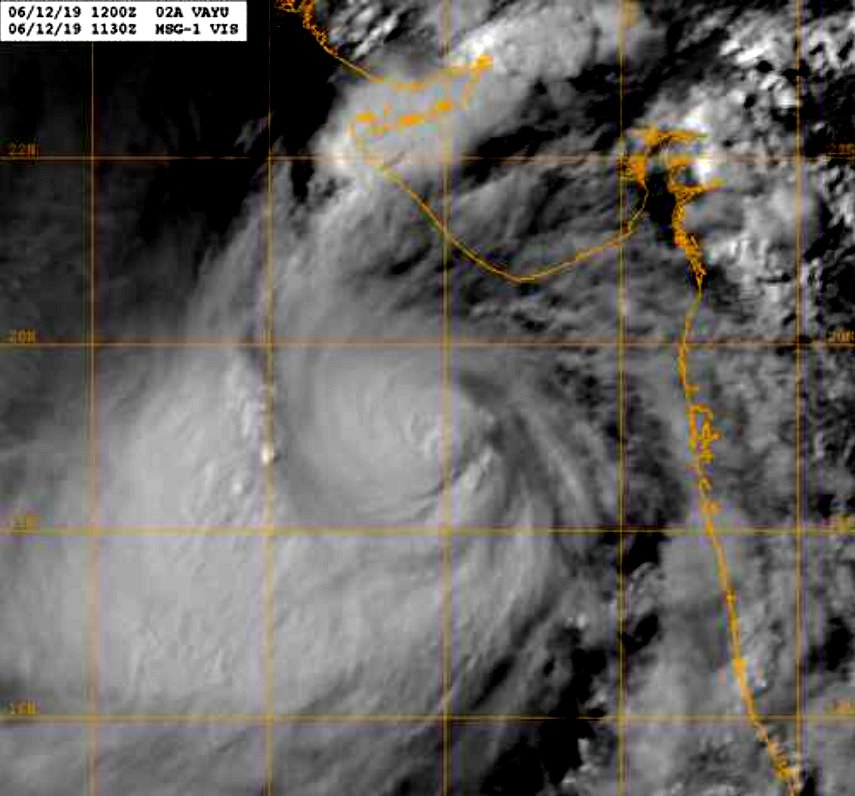
Gandhinagar: The Very Severe Cyclonic Storm ‘VAYU’(pronounced as VAA’YU)over Eastcentral Arabian Sea moved northwestwards with a speed of about 14kmph in last sixhours and lay centred at 1130 hrs IST near latitude 18.4°N and longitude 70.0°E over Eastcentral Arabian Sea, about 310km west-southwest of Mumbai(Maharashtra),280km nearly south of Veraval(Gujarat)and 360km nearly south of Porbandar (Gujarat).It is very likely to move nearly northwards and cross Gujarat coast between Dwarka and Veraval as a Very Severe Cyclonic Storm with wind speed 155-165kmph gusting to180kmph around afternoon of 13thJune2019.After crossing, the system is likely to move along & parallel to Saurashtra & Kutch Coast affecting Amreli,GirSomnath, Diu, Junagarh, Porbandar, Rajkot, Jamnagar, Devbhoomi Dwarka and Kutch. The latest IMD bulletin said.
Forecast track and intensity are given in the following table:
| Date/Time(IST) | Position (Lat. 0N/ long. 0E) | Maximum sustained surface wind speed (Kmph) | Category of cyclonic disturbance |
| 12.06.19/1430 | 18.8/69.9 | 140-150 gusting to 165 | Very Severe Cyclonic Storm |
| 12.06.19/1730 | 19.2/69.9 | 140-150 gusting to 165 | Very Severe Cyclonic Storm |
| 12.06.19/2330 | 20.0/69.8 | 145-155 gusting to 170 | Very Severe Cyclonic Storm |
| 13.06.19/0530 |
20.9/69.8 |
150-160 gusting to 175 | Very Severe Cyclonic Storm |
| 13.06.19/1130 | 21.2/69.8 | 155-165 gusting to 180 | Very Severe Cyclonic Storm |
| 13.06.19/2330 | 21.9/69.6 | 130-140 gusting to 155 | Very Severe Cyclonic Storm |
| 14.06.19/1130 | 22.3/69.3 | 120-130 gusting to 145 | Very Severe Cyclonic Storm |
| 14.06.19/2330 | 22.7/68.8 | 110-120 gusting to 135 | Severe Cyclonic Storm |
| 15.06.19/1130 | 22.9/68.3 | 100-110 gusting to 125 | Severe Cyclonic Storm |
Warnings:
(i) Heavy rainfall warning:
| Sub-Divisions | 12 June 2019* | 13 June 2019* | 14 June 2019* |
| Konkan& Goa | Widespread rainfall with heavy to very heavy falls at isolated places | Fairly widespread rainfall with heavy falls at isolated places | Fairly widespread rainfall |
| Saurashtra& Kutch | Fairly widespread rainfall with heavy falls at isolated places | Widespread rainfall with heavy to very heavy falls at few places and extremely heavy falls at isolated places | Fairly widespread rainfall with heavy to very heavy falls at isolated places |
| South Gujarat Region | Fairly widespread rainfall with heavy falls at isolated places | Rainfall at a few places with heavy falls at isolated places | Rainfall at a few places |
Note: * Rainfall till 0830 IST of next day.
Legends: Yellow: Be Updated; Orange- Be prepared; Red- Take action, Green: No warning
Heavy rain: 64.5-115.5 mm/day; Very heavy rain: 115.6-204.4 mm/day; Extremely heavy rain: more than 204.4 mm/day
(ii) Wind warning
- 12th June: Gale wind speed reaching 140-150 kmph gusting to 165 kmph prevails over eastcentral & adjoining northeast Arabian Sea and become 145-155 kmph gusting to 170 kmph by 12th night. Gale wind speed reaching 60-70 kmph gusting to 80 kmph prevails over Gujarat Coast and become gale wind speed reaching 100-110 kmph gusting to 125 kmph by 12th night. It is very likely to be 50-60 kmph gusting to 70 kmph over Maharashtra Coast.
- 13th June: Gale wind speed of the order of 155-165 kmph gusting to 180 kmph very likely over north Arabian Sea & Gujarat coast till afternoon and decrease gradually thereafter. It is very likely to be 50-60 kmph gusting to 70 kmph over north Maharashtra Coasts & northern parts of eastcentral Arabian Sea.
(iii) Sea condition
- The sea condition is phenomenal over eastcentral & adjoining northeast Arabian Sea & Gujarat coast on 12th & 13th June 2019.
- The Sea condition is very likely to very rough to high along & off Maharashtra Coast on 12th & 13th June, 2019.
(iv) Fishermen Warning
- The fishermen are advised not to venture into Eastcentral Arabian Sea and along & off Maharashtra Coast on 12th; north Arabian sea and along & off Gujarat coast on 12th & 13th.
(iv) Storm Surge Warning
Storm surge of height of about 1.5-2.0 m above the astronomical tides likely to inundate the low lying coastal areas of Kutch, Devbhoomi, Dwarka, Porbandar, Junagarh, Diu, Gir Somnath, Amreli and Bhavnagar districts at the time of landfall.
(v) Damage Expected and Action suggested for Amreli, Gir Somnath, Diu, Junagarh, Porbandar, Rajkot, Jamnagar, Devbhoomi Dwarka and Kutch:
(i) Total destruction of thatched houses/extensive damage to Kutcha houses. Some damage to pucca houses. Potential threat from flying objects.(ii) Bending/uprooting of power and communication poles. (iii) Major damage to Kutcha and Pucca roads. Flooding of escape routes. Minor disruption of railways, overhead power lines and signalling systems. (iv) Widespread damage to standing crops, plantation, orchards, falling of green coconuts and tearing of palm fronds. Blowing down bushy trees like mango.(v) Small boats, country crafts may get detached from moorings.(vi) Visibility severe affected.
Action suggested:
(i) Regulate road & rail traffic (ii) Total suspension of fishing operations. (iii) Evacuation from low lying areas of the above mentioned Districts, coastal Hutment dwellers, urban slum dwellers and people staying in unsafe house to safer places. People in affected areas to remain indoors.(iv) Movement in motor boats & small ships unsafe.(v) Inundation of low lying areas in the along the coasts due to heavy rainfall and storm surge.
DeshGujarat
Related Stories
Union Home Secretary reviews the preparatory measures arising out of the Cyclonic Storm ‘VAYU’
Highlights of Revenue Secretary's briefing on preparedness for Vayu cyclone
Forest teams trying to locate and shift lions in coastal areas to safer places in the wake of approaching cyclone VAYU
Next 50 to 60 hours extremely crucial for Gujarat in the wake of cyclone VAYU: Coast Guard commander
VAYU Effect: Trains to coastal Sauashtra cancelled, short terminated from this evening
Some of the Airports in coastal areas of Gujarat also likely to shut operations in the wake of cyclone VAYU
Cyclone VAYU turns in to 'very severe cyclonic storm', likely to hit Gujarat coast at a much stronger speed than anticipated earlier
Highlights of Dy CM Nitin Patel's briefing on preparedness for Vayu Cyclone landfall
Cyclone Vayu: Ministry of Home Affairs issues detailed advisory to Gujarat and Diu
NCMC Meeting chaired by Cabinet Secretary took stock of the preparatory measures arising out of the Cyclone‘VAYU’
Vayu Cyclone: Shri Somnath Trust cancels Ganga Dussehra programme
Vayu Cyclone: Centre moves 39 NDRF teams to Gujarat and Diu
Shala Praveshotsav postponed, all schools and colleges in coastal districts of Saurashtra - Kutch to remain closed
Union Home Minister Amit Shah chairs a high level meeting on cyclone ‘VAYU’
Cyclone VAYU might further delay onset of monsoon in Gujarat: Met Director Sarkar
Cyclonic Storm VAYU likely to make landfall on June 13 morning somewhere near Veraval coast, no need of evacuation so far: Chief Secretary
In the wake of approaching cyclone VAYU, Ro Ro service suspended from today
Cyclone brewing in sea: Gujarat fishermen asked to return, Signal One hoisted at ports, heavy to very heavy rain predicted in Saurashtra Kutch during 11-14 June
Cyclonic Storm likely in Arabian sea, Heavy rain warning for Saurashtra/Kutch
Recent Stories
- ACB Gujarat files offence against SK Langa and son for disproportionate asset
- Kshatriya agitators announce part-2 programs in Gujarat
- FM Sitharaman on Gujarat visit on April 20th
- JNK India Limited’s IPO to open on April 23rd
- CR Patil files nomination papers from Navsari Lok Sabha seat
- Miscreants attempt to vandalize BJP office in Rajkot
- Amit Shah files nomination papers for Gandhinagar Lok Sabha seat