IMD issues Red Alert for 3 districts of Gujarat; Very heavy rains forecast during next 24 hrs
September 08, 2025
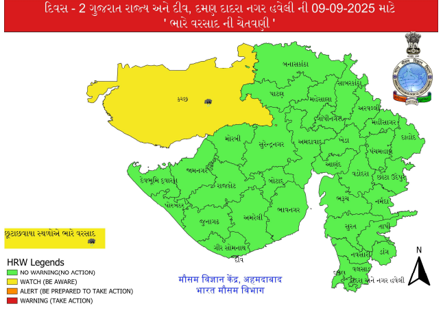
Gandhinagar: The Indian Meteorological Department (IMD) has issued a red alert for three districts of Gujarat for the next 24 hours, as they are likely to receive very heavy to extremely heavy rainfall. According to the IMD bulletin, Kutch, Banaskantha, and Patan are expected to experience heavy to very heavy rain, with extremely heavy showers in isolated areas until 8:30 am on Tuesday.
Additionally, Surendranagar, Jamnagar, Morbi, and Dwarka have been placed on an orange alert for heavy to very heavy rainfall, while Mehsana, Sabarkantha, Rajkot, Porbandar, and Junagadh are on yellow alert.
On Tuesday, a yellow alert for heavy rains has been issued for isolated places in Kutch, while the rest of the state may witness light to moderate rainfall in scattered areas.
In a major relief, the IMD forecasts that from Wednesday, September 10, the intensity of rainfall will decrease, with all districts likely to receive light to moderate rain or thundershowers until September 14.
Synoptic situation:
The deep depression over southeast Pakistan and adjoining Rajasthan & Kutch is moving slowly northwestward at a speed of 8 kmph over the past six hours. As of 8:30 am IST on Monday, September 8, 2025, it was centered near latitude 25.0°N and longitude 70.5°E, about 90 km southeast of Chhor (Pakistan), 120 km southwest of Barmer (Rajasthan), 170 km northwest of Radhanpur (Gujarat), 190 km west-northwest of Jaisalmer (Rajasthan), and 210 km north-northeast of Bhuj (Gujarat).
The depression is expected to move nearly northwestwards across southeast Pakistan and adjoining Rajasthan until Tuesday afternoon. Thereafter, it is likely to move nearly westwards and gradually weaken into a depression.
Yesterday’s trough from the cyclonic circulation associated with the deep depression over North Gujarat and adjoining southwest Rajasthan now extends from the deep depression over southeast Pakistan and adjoining Rajasthan & Kutch to south Punjab across west Rajasthan. It is currently seen at 1.5 km above mean sea level.
The monsoon trough at mean sea level now passes through the center of the deep depression over southeast Pakistan and adjoining Rajasthan & Kutch, then through Kota, Orai, Sidhi, Ranchi, Digha, and continues eastwards to the northeast Bay of Bengal. DeshGujarat
Recent Stories
- VUDA Clears ₹801 Crore Budget, ₹50 Crore Allotted for Ring Road Project
- SC Orders Status Quo in Bhadra Parisar Case; Stays Reinstatement of Street Vendors
- Hindu Minor Lured Into Love Trap, Fake Aadhaar Used to Book Hotel Room; Three Held in Ahmedabad
- Delivery of 10 New Trainsets for Ahmedabad Metro Likely to Commence from June 2026
- AMC Announces Ahmedabad Innovation and Startup Policy 2026, ₹250 Crore Fund Planned